Monday, 7 August 2017

Day 5 Kenmare - Dingle and Slea Head

We knew our ridiculous good fortune couldn't last and today the rains came and stayed.
Kenmare was a really good base and the Hawthorn B&B was perfectly placed on the edge of the town bit with good parking, We failed to photo the high street busy in the sunshine last night after dinner so here it is on a wet Sunday morning including the 2 pubs at which we ate.


Kenmare high street
We set off in the rain to complete the Killarney end of the Kerry Ring commencing with the pass North via Molls Gap. The pass is far from spectacular though the day didn't help and yesterday's Gap of Dunloe experience was more dramatic.

Moll's Gap from south
The next landmark on the Ring is Ladies View and we pulled into a layby short of the main commercial viewing point which was good. Excellent views north and south across lakes and valleys with mountain backdrops.
Ladies' View north
Continuing along the N71 and entering the Killarney National Park, the road wove its way through beautiful deciduous woodland with masses of ferns skirting the roadside. I'll admit at this point that I've taken to calling the Wild Atlantic Way the 'Wibbly Wobbly Way', partly because of the wave symbol on the markers but also because the roads keep weaving.

Laybys provide stopping points to take in lake views dropping toward Muckross and then we see parking for Torc Waterfall on the right. A woodland walk of 5min takes us up to the falls (free) making a nice diversion from the drive. It evens holds on the rain for awhile though it is cooler and windy. There are other walks at the falls from 30m to 2.5hr but we're committed to keep moving.

Torc Waterfall


We passed through Killarney town which looked very pleasant with parkland and parked up Jaunting Carts waiting for customers in the rain.

Leaving the Kerry Ring behind, we continued along the southern coast of the Dingle peninsula in torrential rain. as far as Inch Beach, a spit which sticks out to the south with a stunning beach running along it. The rain had abated slightly and we parked on the sand and with our coats on ventured a walk on the beach for a while watching an amazingly skilful kite surfer though his skill seemed to fail later when he was trying to get the kite in in the strong winds; we watched for a while then gave up and left him to it. As we headed back to the car the rain returned.

Inch Beach parking on the sand

Kite surfing


wet heads

As we left Inch Beach, I couldn't resist a drive on the sand, no logic to it but fun for being unusual.

Heavy rain continued and we had the oft spoken  'atmospheric' views across sea withvheadlands fading to grey one after another. I'd call it dismal.
atmospheric ?
We encountered Dingle for the first time passing through. We have picked a bank holiday weekend to come here and even in the rain the traffic is backed up from the town due to people trying to park. We passed through eventually and continued to Ventry beach, a very nice curving bay. Shortly afterward we pulled into the Stonehouse café for a brief light lunch. When we got back on the road it was 2:40 and getting late fro our planned itinerary.

We stopped at signs for a Pre-historic fort which on entrance presented a €2 each charge paid into a box with a big sign CCTV in operation. We paid in spite of the clearly dummy camera :)  The fort was unlike anything we've seen before and quite interesting even though limited. All dry stone, the massively thick wall can be seen to start curving in in the rooms suggesting he beehive roof structure. Drizzling rather than raining.


Layout of Dunbeg Fort

We were now dring the Slea Head ring we drove on rounding the end of the peninsula of a brief cliff hugging road around Slea Head before pulling into the most Westerly car park in Europe at Garraun Point with views across the sound to the Blasket Islands.

Blasket Isands from Slea Head


We had had a break from the rain but I was very tired of driving and we had some difficulty with roads and directions and ended up heading back toward Dingle over the R559 having missed the last northern bit of the Sleah Head drive. We decided it was no bad thing and continued to cut short and head fro our lodgings.

Now, our accommodation at Dingle had been arranged oddly; our original B&B had cancelled on us to a family wedding and re-arranged to another. Our only communication with the replacement, Ashes, had been via telephone and Google Maps had provided a location on the high street. Arriving in Dingle, it was still crammed with traffic and we circled through the centre of the town three times seeing Ashes but not able to park in spite of being assured that it had parking. Eventually, we pulled up outside town to phone and noticed I'd written Spa Road rather than High Street. A new look at the map showed us to be just off Spa Road and within 3 mins we had found our very nice Ashes B&B with parking. Wrong Ashes! who'd have thought?

We were given a recommendation for the Marina Inn to eat which was the far end of town and it turned out perfect. We walked straight there and got the last 2 seats to eat. The staff were great and the food good but the best was that Sunday night from 5:30 is their open night for musicians and singers and just after 6:30 one guy walked in with a violin and over then next half hour was joined by a mandolin player, 2 accordionists, another violinist, a penny whistle and mouth organ and a percussionist. It was clear most were meeting for the first time and we were in effect witness to a jam session.
Jamming


evening sky

Marina Inn

Dingle lower street

Dingle higher street
After dinner the rain had finally stopped for a while and we had a walk out along the harbour wall before returning to the B&B, a half bottle of wine and surprisingly good Internet connection.

Statistics (from Dublin):

Miles today: 93; Miles so far: 603; Fuel added so far: 30 litres;

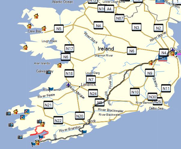
Track Today and since Journey Start: 


Saturday, 5 August 2017

Day 4 Kerry Ring out of Kenmare

Today was based around touring the Kerry Ring but, as with the Wild Atlantic Way, we are using the route simply a base to work from. The Ring is notorious for being congested with coaches that arrive from Limerick and follow the Ring in an anti-clockwise direction (by law) and initially we had considered simply getting ahead of them but after research by Lynne we decided on a completely different strategy which worked well for us.

We were away from our lodgings in Kenmare and on route shortly after 9am heading along the southern edge of the peninsula following a clockwise route. The plan was that by the time we met the coaches we would be leaving the main route to explore the head of the peninsula and only return to the ring route later after they had gone. This allowed us to stop and look at our leisure; the other massive advantage being that pull ins would be on the left of the road and we'd always have the sea view.

A fast road took us to Sneem after which the land opened out to big views varying between sea and high hills. There were some wonderful sea views from the side of the road.


Nearing the end of the peninsula we thought we should explore and, ignoring Lamb's Head, we took the following turn passing Derrymore House and Gardens down to The Strand, a wonderful beach area. We walked some of the beach in the sunshine, out of the wind amongst the rocks it was actually quite warm.  Unlike in England and Wales, we find we can drive to the coast here and not always encounter charged parking even to have a look; here we found good free parking, well maintained toilets and a lifeguard attended beach.

The Strand
We returned to the N70 and main route. Very soon we encountered a spectacular viewpoint over Abbey Island. If coming the other way, this would have been the second layby after the big viewpoint car park where the coaches pull in. The coach park must get busy as stalls were setting up selling fudge and other goodies ready for them.

Abbey Island
The next town was Waterville, claiming fame as a holiday location for Charlie Chaplin. We parked at the side of the road thinking Coffee and Cake at a waterfront Café but didn't find one and after an amble through town carried on. It was 11:45 and we were meeting the leading edge of the coaches now.

Leaving the N70, we headed off into the end of the peninsula toward Ballinskellig. The views out to the Skellig Islands were great, the larger island Skellig Michael, though at a distance 8 miles off, is a fascinating starkly jagged vision; apparently it is used in a later Star Wars film.
Skellig Michael

Our next stop was as we passed the Skellig Chocolate factory and were tempted in. A very good tasting session where one of the staff takes you through pieces of several flavoured and textured chocolate was really interesting - it was also successful as we spent €8 of some hazelnuts pralines. Being lunchtime, we enjoyed the on site cafe's coffee and scones followed by half a raspberry and almond slice each.
Heading on to the Cliffs of Kerry, we stopped briefly at a viewpoint over the wide flood plain valley before dropping down the hill and pulling into the "Cliffs of Kerry Experience", actually a farm which has gradually turned over to providing car park and tracks to access fantastic views of the cliffs. At €4 per person it sounded expensive but they have worked on it and fencing, drainage and insurance cost a lot. Given we had just spent the same on a whim on some chocolate it was a fair price.


Beehive Houses exibition


Kerry Cliffs and the Skerrig Islands


Kerry Cliffs

Quite a few sections of single track road out here at the end of the peninsula but all in good condition.

The afternoon moving on now at 3pm we considered our next steps and decided, for the novelty of a ferry ride, to head over the bridge at Portmagee to Valentia Island and then take the ferry to re-join the N70 back inland. Portmagee itself was a nice little town and we stopped for an ice cream before moving on to a mere 10 min wait for the ferry. (note: the queue on the mainland going the opposite way was about 3 ferries worth, I guess 30-40 mins for the back cars).

Valentia Island ferry
We had hoped to be back earlier tonight and it was now late afternoon as we moved along the N70 not stopping or diverting to locations such as Kells Beach and Bog Village.

Being Bank Holiday weekend we have seen adverts in many town for festivals and passing through the town Cahersiveen soon after the ferry we drove skirting around crowds drinking spread onto the road around pubs; all along the high street individuals and groups of children and adults had set up outside shops with violins, guitars, bodhran, whistles and accordions. Some larger groups played in pub grounds and outside one shop a girl was Irish Dancing on a board. Traffic massively disrupted but crawling through at walking pace with the windows open was a treat.

We realised that we were going to head straight into Limerick and round back to Kenmare when we had intended covering one of the passes/gaps today and decided regardless of the time to return via the Gap of Dunloe.
We turned off the N70 and made progress for a short while before encountering Horse drawn carriages, solo horse riders and walkers. The road was labelled a Priority for horse drawn vehicles and walkers but traffic isn't forbidden. We thought it was late in the afternoon and comparatively quiet and we continued up, threading our way behind and past the horse drawn and foot traffic as well cars coming the other way. It seemed a long way up part of the southern side of the pass to the point where the carriages turned back and we continued the winding steep single track climb to the summit.
8 miles and 1 hour after turning into the pass we got to the other end.

Jaunting Carts on Gap of Dunloe


Gap of Dunloe summit


It is an amazing pass but unless you are feeling extremely patient, comfortable with close quarter passing and reversing tight into walls and ditches, and confident with your gear selection on tight steep corners I would give it a miss. Even if you tick all these boxes, it's difficult not to get frustrated by the many who don't and that you have to make allowance for.
Not stopping other than briefly at the summit as any pull ins are passing places, we made our way over the pass and through the wide Green Black Valley before reaching the two way road at Molls Gap and dropping down to Kenmare and lodgings arriving 9 hours after leaving. Tired!

Statistics (from Dublin):

Miles today: 123; Miles so far: 510; Fuel added so far: 30 litres;

Track Today and since Journey Start: 

Friday, 4 August 2017

Day 3 Groleen - Kenmare

An unexpected treat today as the sun shone on us all day. We started out from Heron's Cove a little late as breakfast didn't start till 9 and everyone came down together so we ended up leaving 10:25 for Mizen Head at the end of the peninsula that we were on. It took us less that 10 mins to reach the almost empty car park surrounded by brilliant yellow Mizen Gorse and Purple Heather only just after opening.
Mizen Gore and Heather
Mizen Head was anticipated as a fairly brief visit but, with the sun shining on us, we ended up not leaving until 12:55 and both loved it. The whole place has been lovingly executed with lovely displays and incredibly pleasant young people staffing it. I can't really explain what captivated us so; we only followed some of the paths in that time and looked down from the bridge to watch a seal in the bay as well as seeing another off the headland, we stared out to Fastnet lighthouse and learned how it had been built, watched waves spill over rocks in all directions, moved through interesting exhibitions including about Marconi's early trans Atlantic radio transmissions. We could have stayed longer.
Fastnet lighthouse 9 miles offshore
 
Fastnet centre shot without telephoto


bridge to light

Seal far below the bridge

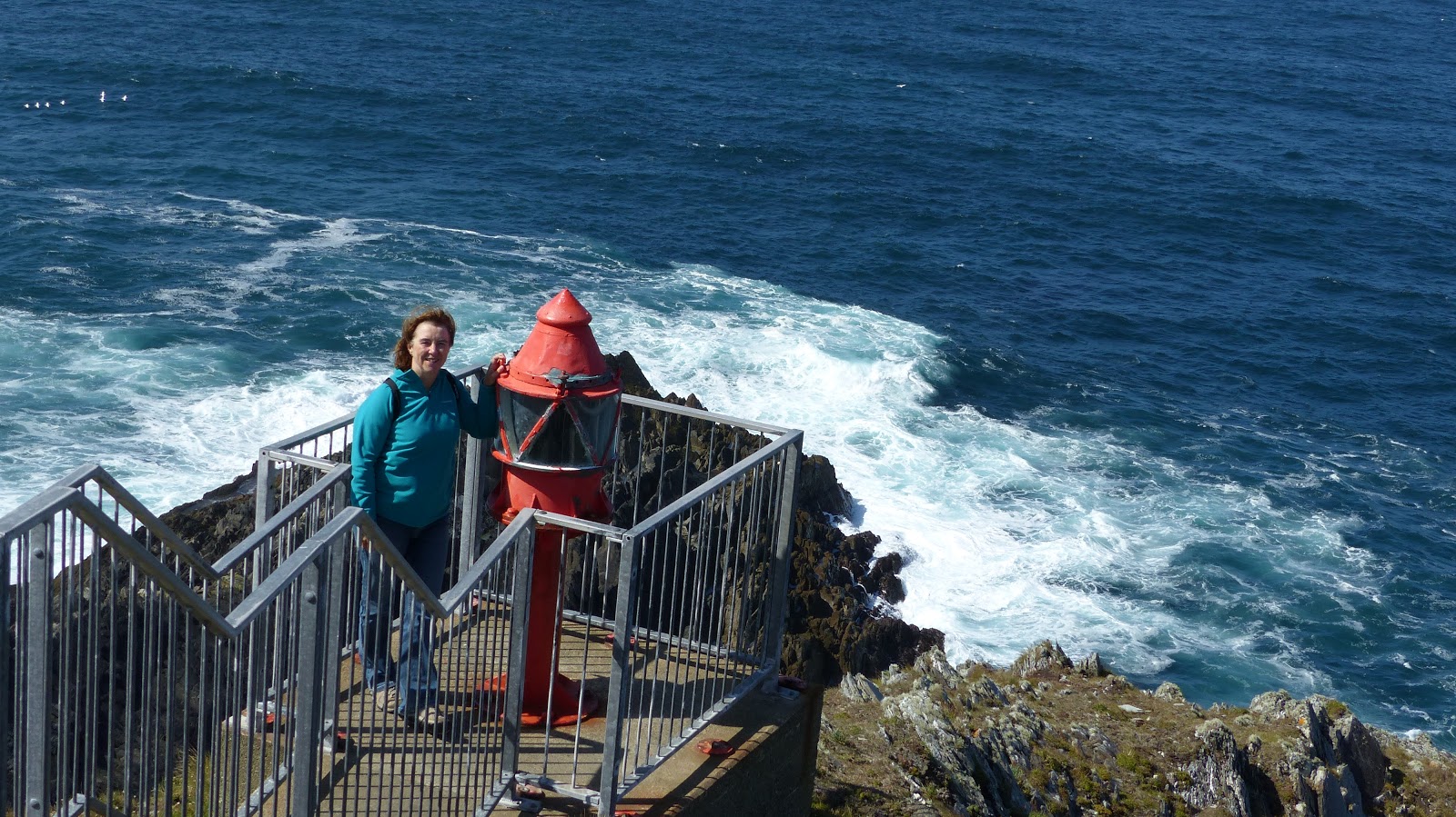
Lynne at the end of the promontory


Another seal off the headland

Already hours behind schedule, this re-affirmed my comments yesterday about not being able to follow the Wild Atlantic Way religiously and so it continued through the day using the Way as a vague line but breaking away from and shortcutting sections.
We left Mizen Head and backtracked past Goleen before turning north on the R591 to the neck of the next peninsula. The 'fingers' of land projecting into the Atlantic are to tops of folds in the rock strata dipping under the sea then rising between so whenever you cross one you climb to height before descending again. As we left the southern coastline we climbed with beautiful views down to the sea.

We were not planning to explore the next finger, Sheep's Head, but drove out along it's southern shoreline as far as Ahakista. The road is right down by the sea and, especially with the sun shining on it, the vistas along the shoreline with islands and inlets were stunning. Ever since arriving in the southwest, many of the smaller roads are skirted with flaming orange flowers occasionally with purple spiked ones amongst them and this road continued this. We stopped just short of Ahakinsta village at a memorial to those lost in an air disaster in 1984 which was a lovely garden path leading to a stone beach where we settled to enjoy a sandwich and quiche we had bought earlier in the day.

View from our picnic on the rocks
It is somewhere near this village that Graham Norton lives and he's certainly chosen a lovely part of the world. They have a carnival in the next few days and in the town the ladders were out to hang bunting.
We took the high road over to Glanlough on the north coast which was narrow and winding with grass growing down the middle. A beautiful road and as we turned inland along the north toward Bantry hills around continued the pleasure.


Wild Atlantic Way signage

We passed through Bantry which was having it's Friday market. We didn't have time to stop and check it out but it was a proper market with toolstores spread on the road and poultry being sold; it looked a big deal.

After Bantry, we headed for the next peninsula, the Beare Peninsula. We had decided there was no way we could get out to the end and see Dursey as it was now getting late but decided to get as far as Castletown and then return to go up and over the Healy Pass. Here we meet out first disappointment; the southern road is largely just a fast wide road, heavily wooded and viewpoints have been allowed to become overgrown so that the views are now blocked. The sections not as wide and fast were very closed in with growth around and only occasionally were sea views appearing. The road was for some reason a hard drive and no pleasure for the driver. We arrived at Castletown to find it not particularly pleasant and with traffic chaos in the centre. We did park for a while by the still working fishing port and did a quick circle thinking we may have a coffee somewhere but found nothing to like and returned to the car to head East back to the pass. In truth, the road was nicer W>E than it had been E>W due to hill backdrops.

Fishing boats at Castletown

Orange and purple flowers along road edges

Turning into the Healy Pass road I was unnecessarily worried by tall hedgerows for a while as it opened up to a spectacular drive up and through a pass fit for the Alps or Pyrenees (on a smaller scale) with views to the sea both North and South from the top. We would strongly recommend a trip over the Healy Pass. Early on at the start of the pass a shepherd had waved us down near a bridge and we thought there was a problem; actually, he just wanted a chat and asked us how our holidays was going and how long we'd been together and what children we had,; lovely fella but we were glad to point out the queue now forming behind us. As we drove off, we saw him go to chat to the next car!
We eventually dropped into Kenmare at 6pm and found our lodgings quickly which are right in town with parking - result!  I really can't believe I only drove 112 miles today, it certainly felt like 200 plus.

Healy Pass


Dinner was in a pub in town but we left before any music got going, largely because the driving,  late nights and far, far too much food is killing me. And now I'm still writing this at 10:30 and I haven't even got any of the photos off yet.  Must sleep soon; wish I had the willpower to say, "No", to a full Irish in the morning but I probably won't.


Statistics (from Dublin):

Miles today: 112; Miles so far: 387; Fuel added so far: 30 litres;

Track Today and since Journey Start: