Sunday, 13 August 2017

Day 10 Journey's End

6:30am alarm! 
Inevitably, didn't sleep at all well last night, awake since 5:20 and feel grotty. Once showered feeling better, packed and ready.

Ferry check in close was 07:50 and only 3.5 miles away, estimate 10-15 mins. To be really safe we decided to leave the hotel by 7:15 which gave us time to wander down to the Exec Lounge where we had been told coffee and croissant would be available from 6:30. Well, breakfast wasn't included in our rate but here we found coffee, orange juice, fruit and a variety of pastries. If time had allowed we could have had a full breakfast  here; as it was we enjoyed coffee and two small pastries and casually ambled back our room, collected our luggage and made our way to reception.

Time disappeared somewhere and it was gone 7:20 as we piled into the car and left but still, we believed, with loads of time. That was before we hit the back of the traffic toward the port. Static for minutes at a time, crawling when moving and held repeatedly at lights, my stomach was going as 7:40 passed. At last we were flowing freely into the port but the road wanders around all over as ports often do and we finally hit the check-in queue 1 minute before it was due to close.
Actually we joined a queue of 8 cars or so, probably also delayed and more were joining behind. I was amused to see the passenger in the car behind hold her hands to her face in blessed relief.

Back on the Stena Adventurer we stayed up top until Dublin had faded behind us. We had expected to eat breakfast but we were both quite content after the earlier snack and is was almost a relief not to force another 'Full Irish' down.

A calm crossing brought us in sight of Anglesey swathed in a blanket of cloud.

Our Irish adventure officially completed we set off across Wales to England and home.

We enjoyed our time in Ireland. If you have come along with us on the blog, we hope you enjoyed it too.


Go dtí an chéad uair eile - till next time (I hope)

If you have an questions just post a comment. The drop down menu allows you to post anonymously so you don't need to use an account. All comments are moderated so you won't see yours appear until I've acknowledged it.

Statistics (from Dublin):


Miles today: 4 ; Miles so far: 1218; Fuel added: 120 litres, half a tank left ~ around 30l.

Track Today and since Journey Start: 

Day 9 Newport - Dublin

The Newport Hotel was lovely, quite grand in feel for this outpost. Just down the road is a grand house where Grace Kelly used to spend time in this area where her grandfather had lived and she'd been fond of since childhood. Appropriate for the name, The Newport hotel is actually the only hotel in town. We guess it's grand nature with panelling and screens reflects the cliental attracted by the Princess Grace guest list.
The staff were, as all over, wonderfully relaxed and friendly and the food and drink excellent. Our room was at the front of the hotel and we looked over a window box full of colourful petunias out  under the stars and stripes flag down the height street. We also both agreed that it was the most comfortable bed we'd ever slept in.
All in all, it was a perfect last hotel on our adventure. Tomorrow is an overnight in Dublin simply as a step to an early ferry on our journey home.

We set off to explore our last bit of the West passing back through Mulranny where we hired the bikes yesterday before turning North on the N59. Initially, we had a view across the sea inlet to the Greenway where we cycled then continued North through miles of peat moorland flat to hills.

At Bangor, we took the R313 before turning into a small road north along the shore of Carrowmoor Lake. Though a decent road and cutting a big corner this was oddly not on the Sat Nav and according to it we travelled off road. A lovely road and we stopped several times to take in the views.


The marks of peat cutting

Carrowmoor Lake
Joining the R314 East the road roamed along surrounded by wetlands and fells, peat and sheep; a lot of the sheep had decided that the road was a good place to sit or stand munching at the verges.

We eventually hit the Sea coast again in some of our last miles on the Wild Atlantic Way. The landscape is more green with pasture fields and clearly farmed rather than 'wild'. We passed Ceide Fields visitor site where they have discovered ancient field layouts but with a tight schedule we decided not to pay to enter and keep going to our next destination Downpatrick Head.


Our last Wild Atlantic Way marker

Downpatrick Head sheep
Approaching Downpatrick Head, more cliffs came into view and we turned off at Ballycastle following signs to the Head. Parking was easy and we walked across lush green grass passing sheep too busy with munching to bother us toward the head and the Stack. The stack used to be an extension of the Head but the land bridge fell away in the 1300s reportedly marooning a family who farmed at the tip. It is said that they were rescued using ships' ropes. If true, it must have been terrifying.
The Stack

Downpatrick Head with RAF WWII look out post

Wild Atlantic Way signage at Downpatrick Head
This marked out last port of call on our journey and we had seen signs for Mary's Cottage Café in the village which suggested a good solution to lunchtime. We actually only wanted a bun and a cup of tea but ended up with a portion of Sea Food Chowder which ticked off another local dish as done.

Suitable fueled, we continued to the large town of Ballina where we fuelled the car as well before waving Good Bye to our last Wild Atlantic Way route marker.

From Ballina it was a straight forward 164ml drive to Dublin, along the N5, N4 and M4 before joining the M50 Dublin peripheral motorway. Beryl (the Peril) our Sat Nav was trying to take us through the City Centre which we thought we wasn't a good idea at 5:15pm on a working day and we repeatedly ignored her. Eventually we thought we'd got the turn for the tunnel to the port but ended up heading out toward the airport. Frustrated, we returned and followed Dublin Port which took us through the tunnel. The tunnel toll this time was €3, the €10 last time was due to time of day.
Having reached the port we now followed the Sat Nav again, hallway back on the surface!

We arrived and parked at the Croke Hotel opposite the stadium. Parking was a big attraction of booking this hotel and it was a good decision.
Checking in, the room type we'd booked was unavailable and we were bumped up to the Executive Floor with a gorgeous room, massive bed and access to the Exec Lounge. It felt very appropriate for our last night in Ireland.
Excellent burger in the hotel bar, our last pints of Guiness and a remaining half bottle of wine in the room, cooled courtesy of the ice machine on the Exec Floor.

Tolls

€2.90 paid at booth near M4/M50 junction, not sure which charge related.
€2.60 appeared on eflow account for M50 (ANPR charged)
€3 tunnel

Statistics (from Dublin):

Miles today: 250 ; Miles so far: 1214; Fuel added so far: 120 litres;

Track Today and since Journey Start: 


Saturday, 12 August 2017

Day 8 Clifden - Newport and Greeway cycle

Leaving the southern counties behind we move into Mayo today, initially travelling through the Connemara National Park. It is our last full day of our journey along the Southwest and West of Ireland following on and around the Wild Atlantic Way.

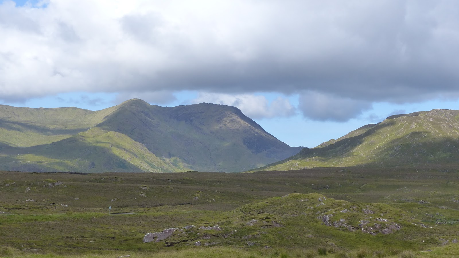
The sun shone on us again and the Connemara mountains turned out be beautiful with wide open wide valleys and a backdrop of mountains or 'Bens'. Similar in feel though not as high as the Scottish Highlands but no less appealing for that.


Connemara Bens
We followed A59 along the Killary Fjord turning off after the crossing to head west along the north shore on a beautiful lakeside drive before turning north to follow the Doo Lough Pass to Louisburgh. This is a gentle pass and an easy drive with wonderful views in all directions.


Small waterfall at start of Doo Lough Pass


From Louisburgh we headed east hugging the coast to Westport and the N59 north to Newport where we were to stay tonight.

This morning had been planned as a short stage as weather permitting we had planned some bike hire for this afternoon on the Greenway and were on target about midday and the weather was looking good.

The Greenway is built on an old railway bed terminating at Achill and can be joined at various points including Newport. We hadn't really discussed which bit we intended or noted distances but after some consultation of maps decided to drive on to Mulranny from where we could cycle around the north coast of an isthmus leading to the bridge to Achill Island. It appeared about 13km each way and we judged that we'd see how it went and turn back when we thought we'd had enough.

Mulranny - Achill

We drove on to Mulranny expecting to find bike hire places along the main road and a bit of a tourist hub; we should have known better. Lynne had identified one of the companies as favourite but we only saw BIKE HIRE signs referring to behind a hotel which we didn't manage to figure out. We called in the tourist info on the main road and before we really knew it, the lady was phoning for 'James' to come down as we wanted to hire 2 bikes. James, a lovely guy, arrived across the road to a parked up old red van and telling us there was no hurry stood in the back of the van topping up the air in the tyres.
Two workhorse Viking bikes came out, not polished and clean but maintained and solid.
We were assured that he didn't mind what time we returned, if he wasn't there just leave the bikes by the van and if the van was gone, by the wall. He echoed what the info centre had said that everything was safe around here. Helmets and high vis jackets were piled on the seats in the front of the van to rummage through and find your own and then James ensured that our comfy padded saddles were at the right height for us.
There was a breeze blowing, though admittedly not much and Lynne asked which way it was blowing wrt out and back, James' response was, "There's no wind", which we suspect was correct relative to most days.
A simple exchange of €15 each for as many hours as it took us sent us on our way.

We had felt that we'd let ourselves be steam rolled a little but the bikes were great, the price was good and the arrangements perfect. We half wondered if James was related to the lady in the info centre; there was certainly no mention of any other company.


Lynne heading off toward Achill
Shortly after leaving Mulranny on the Greenway we did actually pass the original company that Lynne had identified but we were very happy indeed with our Mulranny Cycles mounts.
About half way, at the northern corner of the isthmus we paused and realised that I thought we were going all the way to Achill but Lynne expected we'd probably turn back part way. In the event, we decided we were fresh enough and the ride was very enjoyable with an easy surface and wonderful views and we continued all the way to Achill.
Passing a sign advertising Kath's Café 200m after the bridge we thought that would do nicely. The Greenway passed a Gallery and Café a while before surfacing onto the big main road which would make a good turn around point and is close to where Google Maps identifies Achill. However, we continued on joining the main road and cycling another km or so downhill to the bridge at Achill Sound which was going to be a long climb on the way back. Even after the bridge, we passed buildings for what seemed more than 200m before finding Kath's hidden, due to being stepped back behind other building at the end of a row. Kath was doing good business and rather than wait for a table we had our welcome pot of tea and shared slices of rhubarb and strawberry crumble and apple pie outside..

Our Viking bikes outside Kath's Café
Suitably fuelled up, we pushed our way back up the main road and returned to the Greenway. The return run was very quiet as I guess most hired bikes were off by now. A popular hire is a drop off or pickup one end.

Greenway heading back to Mulranny

Peat cutting


bike pose
On return to Mulranny we felt surprisingly good and were pleased with ourselves when checking my GPS that we'd cycled 19.5 miles. Those extra kilometres at the Achill end add up.
This part of the Greenway is a lovely ride; there are slopes which sometimes go on for a long time but nothing beyond a 1930's steam engine's capability which was not a lot. And, if you do both ways, every uphill has a downhill. Either way, it passes through some stunning scenery.

Achill Sound

James' van

Bikes returned and left leaning on James' van, we headed to Costcutter for a really good 99 ice cream. It had been a lovely afternoon, bright and warm with quite a bit of blue sky. Temperature about 17C so whilst cycling, just about warm enough for tee shirts though we did don our fleeces a couple of times due to cold breezes off the sea.
We drove the short distance back to Newport and our hotel where our view from our window was down the high street and the town looked lovely in evening sunshine.

Bedroom window view - Newport
After a good meal & bottle of wine to celebrate reaching the northern end of our adventure we took a walk down the high street in tee shirt down to river and seven arches. A very pleasant evening before we commence our journey home tomorrow.

Hotel Newport

Seven Arches

Statistics (from Dublin):

Miles today: 86; Miles so far: 964; Fuel added so far: 76 litres;

Cycle: 19.5 miles

Track Today and since Journey Start: 


Friday, 11 August 2017

Some Observations

  • It is virtually impossible to find plain salted crisps. Flavours abound but no Ready Salted.
  • Roads are generally very good. Surfaces are good quality with very few pot holes or edging break up, even on Local roads.
  • The 110 kph speed limit on open Rural roads is misleading. Representing a limit of 60mph, the bends, humps and dips together with width mean that 50mph is usually a more realistic safe top driving speed.
  • Foreign drivers: Whilst we are foreign, we are used to right hand drive manual gear change cars. This is not the case for the many visitors from the USA and mainland Europe and you have to make allowances for them constantly.
  • Most supermarkets seem to have a delicatessen selling sandwiches, quiches and coffee. 
  • There are 3 versions of Wild Atlantic Way signs; \/\/\/\/ (S),  \/\/\/\/ (N) and \/\/\/\/ - no suffix. The first and second indicate a through route South or North respectively, though it may be small road loop going nowhere in particular just staying to the edge of the coast. The third, no suffix, indicates a dead end spur off the route to an interest point along which you will have to return the same way.
  • If you can't see mashed potato with your evening meal, it is probably hidden under something on your plate.
  • Every person we dealt with in shops, attractions, lodging, cafes, restaurants and bars was welcoming, smiley, helpful and patient. The people are delightful including the younger staff who could be expected to be surly and bored if true to stereotype.

Thursday, 10 August 2017

Day 7 Ballyvaughan - Clifden

We left Ballyvaughan Lodge under grey skies but with blue bits appearing here and there. Today was an uncertain day moving North passing Galway but with no specific aims. At this stage of the road trip it's easy to start to feel weary.


looking back to The Burren
We headed for Galway with the grey hills of the Burren behind us. Our plan didn't involve stopping at Galway and we skirted the south of the City not really seeing any architecture. I was looking for an ATM and though we saw a couple of banks we couldn't park; on the way out we spotted a Tesco extra and pulled in to get some more euros.

After Galway we continued along coastal roads before turning north between mountains and wetlands. Running parallel to main road we gained height passing inlets and mountains with the land around us strewn with massive rocks. The road edges were full of lovely purple and yellow.
Near Toobaloo, we came across people warning caution of a bike event and as we passed through Roundstone a huge banner announced the Finish line for the 'Tour de Bog'.


It was getting late and we were struggling to find a lunch stop, we spotted a beach on the map which looked likely but missed the tiny turn. Further on we spotted a small quay projecting out into the loch and pulled onto it. The quay turned out to be a wonderful spot and we got the chairs out in the lee of the wind by the car and passed a very content 40 mins in the sun; a perfect picnic spot.


View from quay


Cormorants drying wings on a rock


The Quay
Just as we packed up the rain started to patter down so we drove off very pleased with ourselves.

We were still thinking that it would be nice to have a walk on a beach but missed Dog Bay. Spotting an  obscure track which appeared to lead to a beach we turned off. There was small concrete sea wall we could pull onto. The sand by the wall was covered in bits of crab shells and the fisherman's gear was all about. Dropping down onto the sand it was a lovely spot with white sand and stunningly clear sea in a series of small bays. Walking with our jackets zipped up from the wind, the sun had come out and we ambled around looking at shells. Finally, it was irresistible and the shoes and socks came off for a paddle.

sea and sand


time for a paddle
We arrived at Clifden our stop for the night not long after the beach walk but, as we wanted to drive the Skye Road before booking in and it had turned into a stunning evening, we drove straight on. The Skye Road consists of a drive out west along a narrow peninsula and return along the top. Driving slowly as there are almost no stopping points other than at the end, the views across the sparkling blue sea were amazing. The greens of the hillsides shone in the sun and heather, gorse and fuscia added purple, yellow and red to the palette.


At the end of the Skye Drive we quickly arrived at the Dun Rhi guesthouse in Clifden and settled in.

Evening meal was at Mannion's bar where we chose the Irish Stew as we hadn't had one yet and it was really good. We ate to the accompaniment of live music from a couple switching between guitar, fiddle, banjo and accordion. Apart from the familiar sounds of Leaving of Liverpool and Whisky in the Jar is was largely instrumental. It seems to me that most Irish tunes sound virtually the same with just a few signature differences. There is a degree of heard one, heard most but still entertaining.

Statistics (from Dublin):

Miles today: 131; Miles so far: 878; Fuel added so far: 76 litres;

Track Today and since Journey Start: 


Tuesday, 8 August 2017

Day 6 Dingle - Ballyvaughan

Largely seen as a travel day today we set off initially crossing Connor Pass. The morning was grey with low cloud and occasional drizzle but under the cloud the views were clear and at the summit we could look back to Dingle on the south of the peninsula and forward to the northern coast. Below us we could see complex layouts of farm walls we guess stretch back to the pre famine days.

Connor Pass summit view to Dingle (south)

Connor Pass summit view north

Farm layouts belowthe summit
The pass is an easy drive up from the South but there is a narrow section on the northern side. It is an impressive route making an attractive alternative to the main road. Descending further we pulled in by a small but fully formed waterfall.

Waterfall off Connor Pass


can't read notes - come back to this bit

By Castlegregory we turned off to a very nice beach for a brief airing before continuing towards Tralee along pleasant easy roads between coast and hills. Following our satnav Beryl (named after Beryl the Peril of the comic for its tendency to take of crazy routes in the Alpes) we passed straight through Tralee rather than using the signed route but being Sunday it wasn't an issue and the town is quite attractive very much reminding us of French towns.
Onto the N69 and a fast clear run all the way to Tarbert for the Shannon Ferry. Our arrival at the ferry was 10 mins after one should have departed but we were waved straight on and the gates immediately closed for departure.

Shannon Ferry

Sister boat going the other way
A very pleasant 15min crossing over the Shannon in sun but cold winds and we were on our way again but looking for lunch. We passed through Kilrush seeing nothing and headed for the coastal town Kilkee which turned out very busy, well we have chosen Irish bank holiday weekend. It's maybe a good job the weather's not particularly good or it would be worse.
We circled the town a couple of times then were lucky to get a roadside spot outside the bakers. Unfortunately, this baker didn't sell sandwiches but we bought some mixed fruit scones. Shortly after we go a spot near a supermarket where we bought coffee and hula-hoops.
Driving along the promenade we headed out to the edge of town and sat in the car out of the blustery wind for lunch.


Kilkee lunch view
A landmark for today was planned as the Cliffs of Moher and we were upset to see a large sign leaving Kilkee that the car parks were full and not to visit till after 5. This was an issue as already nearly 4 we had more journey to complete after the cliffs. A period of indecision and frustration followed before we decided to go anyway. as it was, we did get into the car park though it took about 20 mins to then get a space.
After parking things looked up. The sun had come out properly, indeed we actually go hot walking the cliffs.
At the southern summit it was frustrating to see that had we taken an earlier turn to a "Walk the Cliffs" sign, the car would have been quite close and we would have had access to the paths, just not the visitor centre which we didn't visit anyway.

first impression of the Cliffs of Moher

Lots of people

Cliffs of Moher


zoomed in on the Stack


people on the tops
We walked along the tops of the Cliffs and left again after about an hour heading to the Burren.The Burren is a very large area and it was unclear to us what it was and were it was; descriptions such as 'like somewhere on the moon' didn't gel with the rolling countryside and forest we saw ass we toward Kilfenora.

An old building standing near a corner Kilfenora

Unusual Limestone Drystone wall
About 6 miles south of Ballyvaughan we saw signs for a Portal Tomb and pulled into the carpark for a look.

Limestone Country

From here on we began to understand the Burren. Leaving the car park on the path to the tomb we were presented with amazing limestone pavement over a vast area. The tomb site is superb place to appreciate, examine and walk on this amazing geological oddity.


Limestone Pavement at The Burren

Portal Tomb

A tiny bit of The Burren.
Continuing north to Ballyvaughan and our B&B we appreciated the scale of the Burren as massive hills are all grey colours and sculpted with the carboniferous limestone at the surface. Overall impressive but the close up experience near the tomb is highly recommended.

B&B found and luggage inside we walked down the bar at the West Atlantic Lodge for good beer and food.

Statistics (from Dublin):

Miles today: 144; Miles so far: 747; Fuel added so far: 76 litres;

Track Today and since Journey Start: